Location
Find out what exists at a particular location, for example, a zip code, or a geographic reference, such as latitude and longitude, or address.
It’s as simple as asking! We help you ask relevant questions so that you can make critical decision based on credible spatial information quickly and reliably. Get insights now!
Our missionis to enable you make critical decision. We run the spatial analytics on data to derive information that help you make those decision faster, reliably and cost-effectively.
Leverage powerful visualization of spatial information via maps and visual analytics crucial for decision-making, public awareness rising and strategic assessments.
We help decision makers derive and visualize spatial information needed to make spatial decisions fast, accurately and cost-effectively through our on-demand spatial analytics. All you need to do is just ask, and we do the rest
GAMA enables you to derive critical and important information that leads to better understanding of complex issues. Our analytics platform makes it easier, faster and cost-effective when it comes to delivering information needed for spatial decision making.
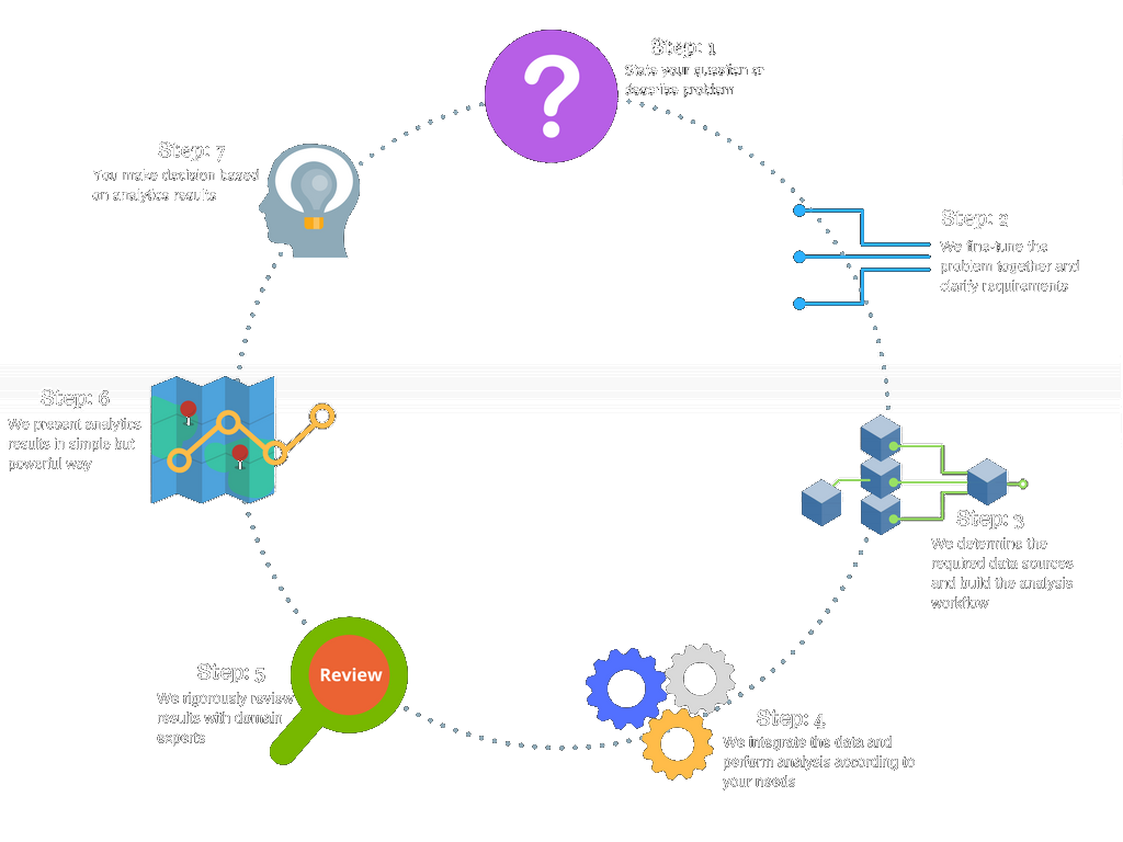
You only need to ask, leave everything else to us. GAMA is your cloud native on-demand Geospatial analytics as a Service that empowers you as a decision maker to derive critical spatial information needed to make decisions quickly, accurately and cost-effectively.
Do what you do best - Spatial Analytics. We empower you with all that tools to conceptualize, design and build those mission critical spatial analytics workflow to answer spatial questions in order to derive insights quicker,accurately and efficiently for businesses and organizations.
We let you make decision based on credible information and data through our on demand geospatial Analytics.
Start asking NowFind out what exists at a particular location, for example, a zip code, or a geographic reference, such as latitude and longitude, or address.
Find the differences within an area over time- What is new, what is changing over a time?, Whats the rate of change at a given place?.
What anomalies are there that don't fit the pattern and where they are located. Get a sense of the overall pattern of features and their associated.
Determine what happens, for instance, when a new road is added to a network, or if a toxic substance seeps into the local groundwater supply.
See that important connection. Find service areas around any location on a network.Make decisions on whats the best route? whats closest facility?.
Identifying what exists at a given location where certain conditions are satisfied, for instance when siting a new facility or school in an area.

Praesent sapien massa, convallis a pellentesque nec, egestas non nisi. Vestibulum ante ipsum primis in faucibus orci luctus et ultrices posuere cubilia Curae; Donec velit neque, auctor sit amet aliquam vel, ullamcorper sit amet ligula.
Read more
Praesent sapien massa, convallis a pellentesque nec, egestas non nisi. Vestibulum ante ipsum primis in faucibus orci luctus et ultrices posuere cubilia Curae; Donec velit neque, auctor sit amet aliquam vel, ullamcorper sit amet ligula.
Read more
Praesent sapien massa, convallis a pellentesque nec, egestas non nisi. Vestibulum ante ipsum primis in faucibus orci luctus et ultrices posuere cubilia Curae; Donec velit neque, auctor sit amet aliquam vel, ullamcorper sit amet ligula.
Read moreWe are here to help you and your organization or business. Please feel free to reach out to us with your questions and comments.